Geographical Setting
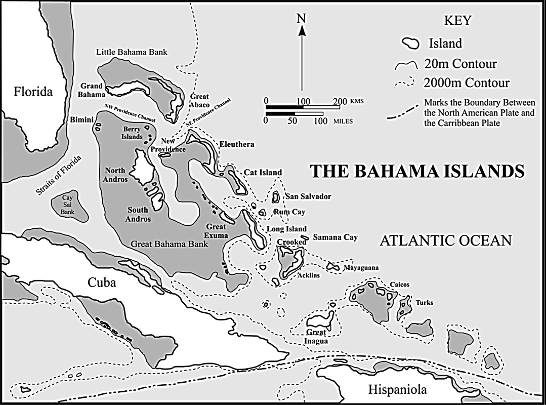
The Bahamas and surrounding regions. After Carew & Mylroie (1997)
|
The islands of the Bahamas lie near the southeastern tip of Florida and just north of the Greater Antilles (Cuba, Hispaniola, Puerto Rico, Jamaica, and the Cayman Islands). For the most part, they define the northern edge of the Caribbean Sea and, together with the Turks and Caicos Islands, form the Lucayan Archipelago. While the Bahamas are composed of over 700 islands and cays, only about 30 are permanently inhabited. The shallow elevation of the islands put many at risk of flooding and make soils difficult to establish.
Looking at the map to the left (after Carew & Mylroie, 1997), the dark grey areas indicate the extent of the submerged carbonate platform upon which the islands form. In these regions, ocean depths remain shallower than about 20 m, but quickly drop off due to the steep slope at the edge of the platforms. |
Carbonate Platform
|
The islands are composed almost entirely of biogenic (biologically produced) carbonates and are built during times of marine transgression (increasing sea level). During these events, corals and other marine organisms establish themselves on the submerged surfaces and begin to build new reef complexes. When sea levels level off at a maximum height, the reefs can build tall, adding mass to the island. Marine regression (decreasing sea level) eventually follows and exposes these newly formed reefs to the surface. The exposed reefs provide the carbonate material that gets added to the island's mass and get altered by surficial processes such as pedogenesis (soil development) and karst formation.
While all of this is going on, portions of the island may still be left exposed during marine transgression. These exposed carbonates can still be modified by wind-driven, or eolian, processes. The most common result is the formation of eolianites, or carbonate dunes, that can become solid rock and preserved. Eolianites are abundant on Bahamian islands and serve as evidence for past sea level changes that have effected the island. Although these processes are not unique to these islands, the Bahamas are a perfect example of how islands evolve over carbonate platforms. |
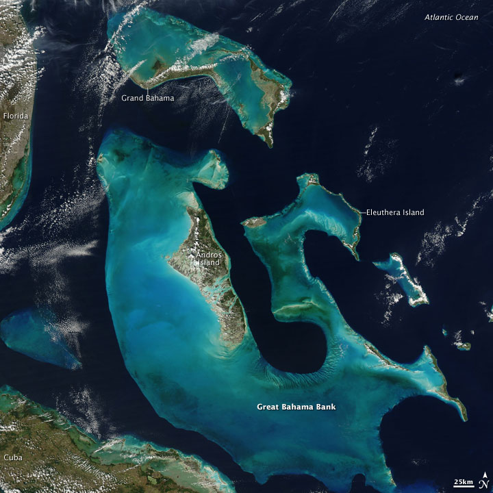
The Bahamas photographed from space via the NASA Aqua EOS PM-1 satellite. The carbonate platforms are recognized by the light blue to green coloration surrounding the islands. Photo: NASA
|
Building an Island
Below is a visual representation of how carbonate islands evolve due to changing sea levels. All diagrams after Carew and Mylroie (1997).
Karst Processes
|
In chemistry, pure water is a neutral substance: not acidic, not basic. However, rainwater is somewhat acidic due to the trapping of carbon dioxide in water droplets, creating weak carbonic acid. When exposed to these acids, the carbonates that build the islands react and dissolve. As a consequence of its tropical geography, the Bahamas experiences lots of precipitation, so the island carbonates become sufficiently weathered to develop what is called a karst landscape. As a result, many caverns and caves are found on the islands, as well as sinkholes that act as underground conduits to the ocean (called 'blueholes'). Because of these conduits, many inland bodies of water are hydrologically connected to the open ocean and behave according to the tide.
|
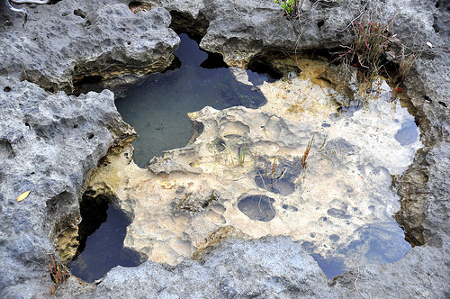
Karst dissolutioning processes have given this carbonate surface a "Swiss cheese" or "moon rock" appearance near Pain Pond, San Salvador Island, Bahamas. Photo: James St. John
|
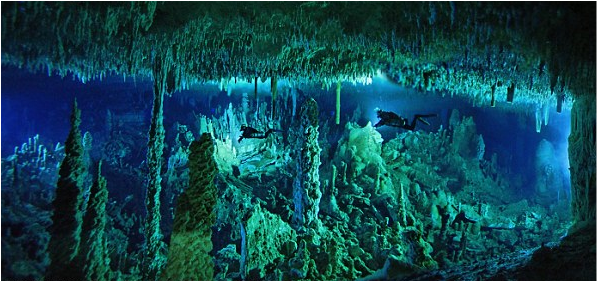
Divers exploring Dan's Cave on Abaco Island, Bahamas. Photo: Wes Skiles
Interpreting the Past
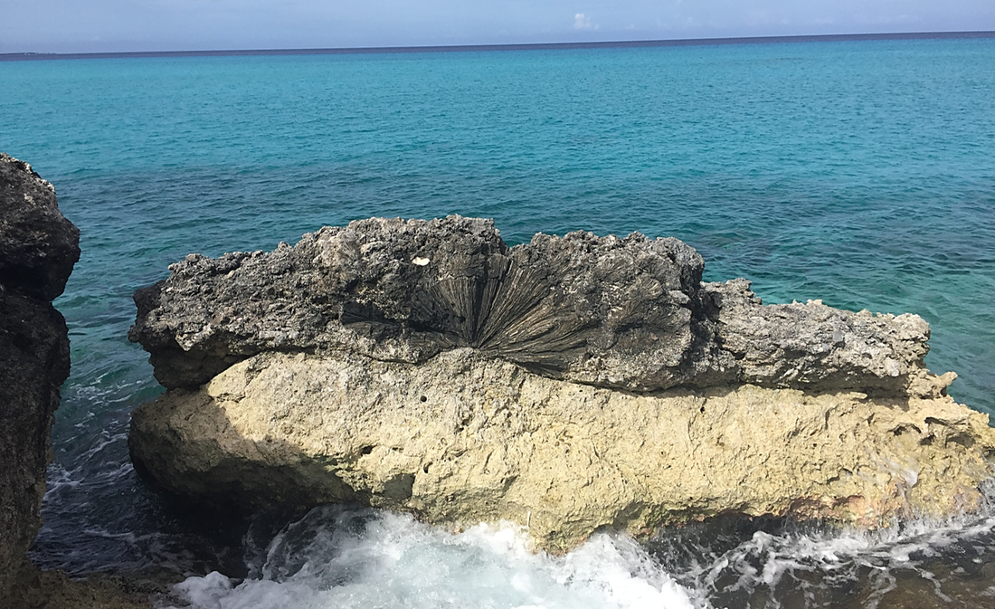
Fossilized brain coral (Diploria) from the Cockburn Town Fossil Reef (Cockburn Town Member, Grotto Beach Formation, Upper Pleistocene), San Salvador Island, Bahamas. Photo: Broc Kokesh
|
Geologic time is so vast that many of the processes described above cannot be observed directly. Tectonic plate motion, sea level change, and coral reef growth occur on the order of only millimeters to centimeters every year. So how do geologists interpret date these events that happened thousands to millions of years ago? The simple answer is that we read the rocks!
Imagine that layers of rock are much like pages in a history book. We can learn about what happened in the past by analyzing the features within the rocks just as we can read information on a page. However, the rocks can be a bit messy, as if the words on a page are all mixed around. Part of being a geologist is to reorganize the information to get the most plausible story on what happened. In the picture to the left, a darker rock layer containing coral fossils sits above a lighter color layer with no such fossils. We interpret this sequence as a part of the ocean floor during marine transgression. As sea level rose, corals were able to colonize the area and begin building a reef complex. Combined with a plethora of analytical techniques from seismology to geochemistry, geologists are able to piece together Earth's deep past. |
References:
Carew, J.L., and J.E. Mylroie. 1995. Depositional model and stratigraphy for the Quaternary geology of the Bahama islands. In H.A., Curran and B. White. Eds. Terrestrial and Shallow Marine Geology of the Bahamas and Bermuda. Geological Society of America Special Paper.
Carew, J.L., and J.E. Mylroie. 1997. Geology of the Bahamas. In Vacher, H.L., and T.M., Quinn. Eds. Geology and Hydrogeology of Carbonate Islands. Elsevier Science Publishers.
